Hiking, trail running and cycling
- Draw a route, or an automatic loop
- Profile, gradients and ground surfaces
- Points of interest, sunlight, arrival time
- Correct and clean up a recorded track
Import a GPX file to cut, merge or clean it up, or draw a route from scratch. Then check the terrain and the weather, on land or on water. Free, no account, right in your browser.
On foot, by bike, on the water, or for others: choose your way in.
Hikers, trail runners, cyclists, kayakers: each feature solves a real problem when preparing or cleaning up a track.
Place points on the map: the routing follows the network for your activity — hiking, road cycling, gravel, MTB, bikepacking, car, or waterways for kayaking. The profile builds up as you go. The automatic loop finds a route from a starting point and a distance.
Drag and drop one or several files. Garmin FIT reads directly, with no prior conversion. Several tracks can sit in the same session and be edited together.
Pick up a recorded route and add kilometres to either end, with automatic routing. Handy for turning a familiar outing into a longer loop.
Cut in two with one click on the map or on the elevation profile. Or split automatically at regular intervals — every 10 km, every 2 hours — for the stages of a multi-day trip, or to hand each section to a waymarker. Each section becomes a separate track.
Merge glues your files end to end, automatically reordering segments so the ends meet. Combine analyses intersections between crossing tracks and suggests up to 5 viable loops.
Flip a route with one click, move the starting point on a loop, warp the track with tags, or switch to point-by-point editing to remove GPS glitches one at a time. Everything is undoable.
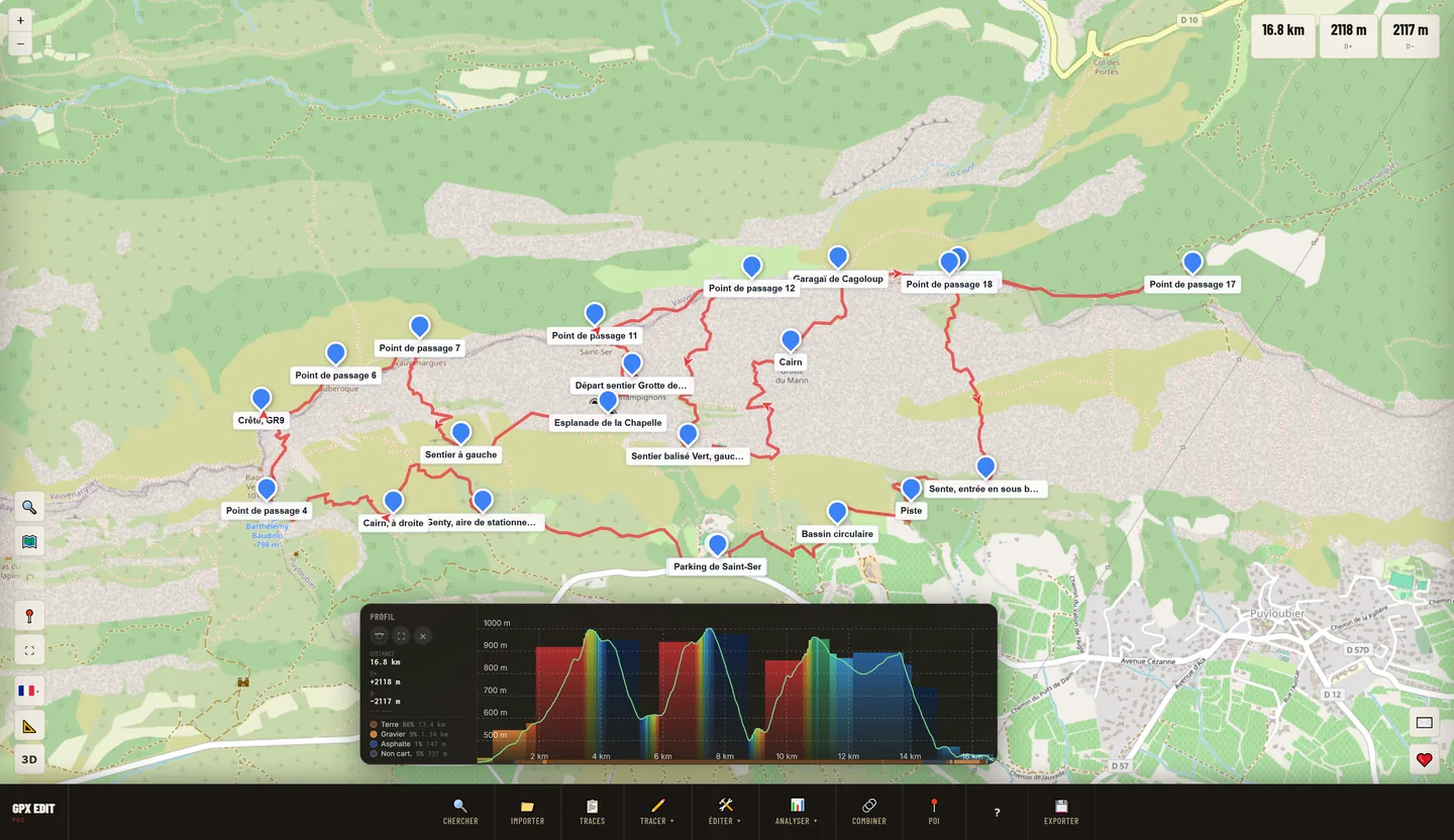
Interactive profile as soon as you import: hover the curve to find each climb on the map, select an area to extract a segment. Gradient colouring highlights steep sections before you set off.
The track is coloured by its mapped or estimated surface from OpenStreetMap: asphalt, paved, compacted, gravel, dirt, grass, rock, sand. A chart gives the breakdown as percentages — you know which tyres to fit.
OpenStreetMap POIs along the route: mountain huts, campsites, water points, bakeries. Sunlight shows the shaded stretches based on the terrain and the woodland. The route card gives the passing time at each waypoint and warns you if you will arrive after dark.
Elevation correction removes barometer drift using IGN terrain data in France and Copernicus elsewhere. Clean up removes GPS spikes and the clusters of points recorded during breaks, with a preview before you confirm. Simplify cuts a 50,000-point file down to a few thousand without distorting the track.
Standard GPX export compatible with Garmin, Wahoo, Suunto, Bryton, Polar, Coros, Strava, Komoot and RideWithGPS. Or an A4 PDF map with profile, waypoints and route card, ready to print.
Generate a unique link and its QR code. Your companions open a page with the preview, the distance and the elevation gain, then the track in their own editor — with no account on their side. It is the only feature that leaves your browser: the shared track, like the shared 3D view, is stored in a JSON file on the server — otherwise the link could not open for the recipient.
For kitesurfing, wing foiling, windsurfing, surfing, sailing, sea kayaking and paddleboarding: the weather map, free, no account.
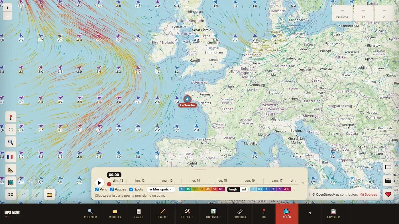
The routing also follows rivers, and follows the coast where there are no more paths.
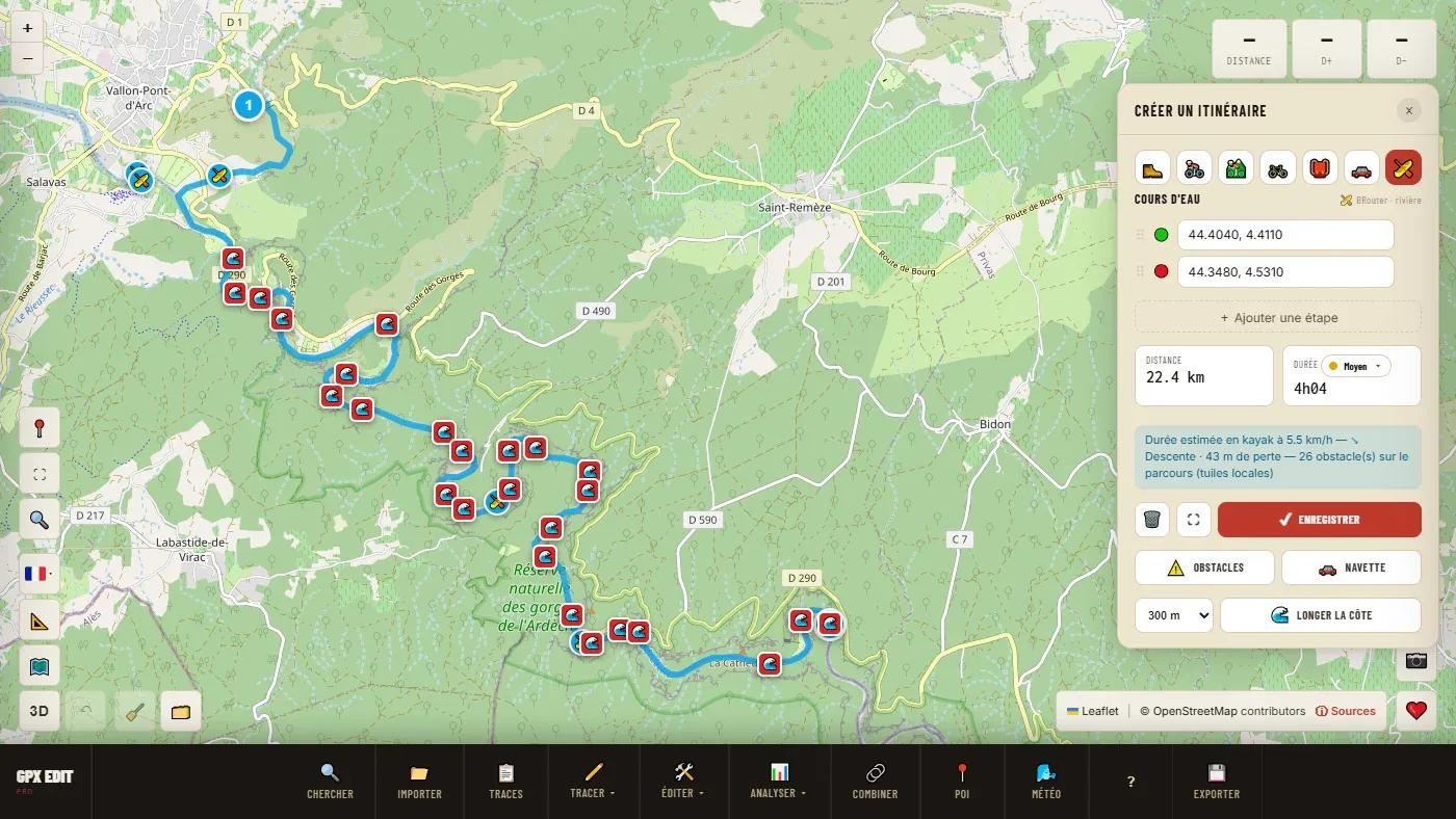
An elevation profile tells you how much you'll climb. 3D relief shows you what it actually looks like.
GPX Edit Pro reads files from your GPS devices and sports apps: Garmin, Wahoo, Suunto, Bryton, Polar, Apple Watch, Coros, Sigma and many others.
What doesn't show at first glance, but makes itself felt from the second session onwards.
Choose the profile that matches your outing: hiking, road cycling, gravel, MTB, bikepacking, car or waterway. The engine calculates a realistic path on the right network — not the same roads for a gravel rider as for a cycle tourist.
Import tracks that cross each other. The algorithm builds a graph from the intersections, discards dead-end turnarounds and suggests up to 5 viable loops from that path network.
Surface mapped or estimated from OpenStreetMap, in 8 categories (asphalt, gravel, dirt, grass, rock, sand…) via PMTiles vector tiles. Breakdown shown as percentages on the track.
Elevation correction relies on IGN RGE ALTI terrain data in France (a grid of about 7 m) and on Copernicus GLO-90 elsewhere (90 m). It removes the slow drift of the barometer without erasing what it measured correctly. The calculation uses your track's coordinates — without sending the file to a server.
7-day forecasts for any point on your track. If the route climbs, a column shows the conditions at the high point. For wind, waves and tide, the weather map takes over.
Search along your track for every useful shop: supermarkets, bakeries, pharmacies, petrol stations, fountains. And accommodation too: campsites, mountain huts, hotels, guesthouses. Filter by category, view them on the map, add a stop in one click. Essential for planning a self-sufficient crossing.
Your changes are kept in your browser: close the tab, reopen the editor, and your tracks and waypoints come back. Nothing is sent to a server. To keep a durable copy or switch devices, export your workspace with My workspace; photos have to be re-imported.
Practical advice for hikers, cyclists, trail runners, kayakers, kitesurfers and organisers.
Dirt, gravel, tarmac: know what you're riding on before you load the bike.
Direct FIT import, common fixes and re-export to another device.
Ascent, descent, elevation correction and gradient colouring.
Markers, stage splitting and a road book for a multi-day trip.
Drop points on the map and let routing plot the real path.
A link and a QR code, with nothing for the recipient to install.
An estimate that accounts for the real terrain, not just an average speed.
Two tracks, one panel, to decide between two options.
Simplify without distorting, when a unit refuses to load the track.
The full method, from the first point to a file ready to take with you.
Follow the coast, choose your slipway, spot offshore wind, read the tide.
Wind, gusts, offshore wind, and the next window that matches your conditions.
One section per waymarker, passing times, the PDF map for the day.
Questions asked by hikers, cyclists, trail runners, kayakers and kitesurfers before planning their outings.
Import your file, enable the Cut tool, then click on the map or on the elevation profile. The track splits into two independent files, exportable separately.
Import your files at the same time, select them in the track list, then click Merge. The assembly order can be optimised automatically so the ends meet. A single GPX file comes out, ready to export.
Merge glues tracks end to end. Combine analyses intersections between several crossing tracks and generates up to 5 viable loops with no dead-end turnarounds — useful for assembling small local routes (trail paths, MTB loops, hiking tracks) into bigger loops.
In the Analyze menu, turn on Surface by color. The track is coloured by its mapped or estimated surface (OpenStreetMap) in 8 categories: asphalt, paved, compacted, gravel, dirt, grass, rock, sand. A chart shows the breakdown as percentages.
Analyze → Weather here gives the 7-day forecast at the start of the track, or at the spot you right-click; if the route climbs, a column gives the weather at the summit. The Weather button in the toolbar opens the wind, wave and tide map.
Select your track and click Reverse. The route flips in one click — handy for turning an outbound leg into a return leg.
Use Correct elevation in the Edit menu. The tool compares your profile with the terrain: IGN RGE ALTI in France, Copernicus GLO-90 elsewhere. It removes the slow drift of the barometer and keeps the details it measured correctly; points without elevation take the terrain value. The calculation runs in your browser.
Simplify in the Edit panel. The Douglas-Peucker algorithm reduces the number of points while keeping the track's overall shape. Set the tolerance in metres and see the result live — a 50,000-point file can drop to 3,000 with no visible distortion. Essential for GPS devices with limited memory.
Click Draw → Via routing in the toolbar and place points on the map. The routing finds the path for the profile you choose: hiking, road cycling, MTB, gravel, bikepacking, car or waterway. Export to GPX when it is ready.
Import your .fit file directly — GPX Edit Pro reads Garmin FIT files with no intermediate conversion. The elevation profile and statistics show up immediately. Then export to standard GPX, compatible with every sports platform.
Cut at the start of the section to remove, then at the end. Delete the middle piece. Merge the two remaining pieces back together. Or switch to Edit points mode to remove points one by one.
Split by interval in the Edit menu. Choose a distance (for example every 10 km) or a duration (every 2 hours) — each section becomes a separate track that can be exported on its own. Handy for the stages of a multi-day trip, or for sharing out the waymarking of a race among several volunteers.
The Weather button in the toolbar opens a map of animated wind and waves over 7 days. Clicking a spot gives the forecast table in 3-hour steps: wind, gusts, direction, offshore or onshore wind, waves, period, water temperature, tide and coefficient. Save your spots and your conditions: the tool tells you the next window that suits you.
Create a route with the Waterway profile: the routing follows navigable rivers and canals and shows the direction of the current and the duration. Hazards finds the mapped weirs, dams and rapids; Shuttle works out the return trip by car. At the seaside, Follow the coast draws a route 150 or 300 m from the shore. → Kayak and paddleboard
Enable Points of interest (POI) and filter by category: mountain huts, guesthouses, campsites, fountains, supermarkets, bakeries, pharmacies, petrol stations, car parks, passes, summits. Click a POI to automatically detour your track through it, then rejoin the main route. Essential for planning food stops and accommodation on a multi-day trip.
The elevation profile shows as soon as you import a file. Enable Gradient by colour to see steep sections on the map — green for flat stretches, red for severe climbs.
Open the 3D visualisation from the editor, or directly on its own dedicated page, then load your file. The terrain is rebuilt from a digital elevation model with the track placed on it, at the correct relief. You can rotate the landscape, overlay several variants to see which one actually skirts the slope, and run a flyover video that follows the route start to finish.
Yes. GPX export uses the universal format, compatible with Garmin Connect, Wahoo ELEMNT, Suunto, Bryton, Polar, Coros, Sigma, Strava, Komoot and RideWithGPS.
No, unless you create a share link. Import, editing, analysis and export all happen entirely in your browser: your files never leave your device. The one exception is sharing — a track or a 3D view — which stores the route in a JSON file hosted on the server, since otherwise the recipient couldn't open the link. Optional features (weather, elevation correction, routing, POIs) contact external services, which receive, among other things, your IP address and the coordinates needed for the calculation. Details in the privacy policy.
Yes. The interface is optimised for mobile with a tool dock at the bottom of the screen and touch-friendly buttons. Works on Chrome, Firefox, Safari and Edge, on Android and iOS. The main drawing, editing, analysis and export features are adapted to phones. Some advanced features, notably Reshape and 3D video creation, need a computer (details in the manual).
Yes. GPX Edit Pro is entirely free: no adverts, no account to create. Every feature is available with no restrictions — editing, surface analysis, weather, PDF export, activity simulation and sharing.
Draw or edit your route, check the terrain and the weather, take the track with you. No install, no account.
Open the GPX editor for free →
Edit a GPX track in 4 steps
No installation, no account. Your GPX editor is ready in a few seconds.
Import your file
Drag and drop a GPX, FIT, TCX or KML file — or build a route from scratch directly on the map. Import several tracks at once.
Analyse the route
Interactive elevation profile, gradients, surfaces, sunlight, weather, route variant comparison — everything is shown in real time.
Edit and plan
Cut, merge, reverse, reshape, clean up, correct elevation, add POIs and waypoints — every operation can be undone.
Export and share
GPX, KML, TCX, A4 PDF map or share link with QR code — compatible with all GPS devices and sports platforms.